


Remote transfer for EODATA
If you manage projects based on Earth Observation satellite data, you know exactly what bandwidth is required and how much space is needed to maintain and transmit this data.
That is why CREODIAS provides you with great capactiy to process EO data directly in the cloud without the need for download the data and with immediate access to the entire Copernicus data repository.
Check out the possible options HERE
Have you ever experienced long lead times due to limited bandwidth and queues in publicly available repositories?
What if You do not have cloud resources on the CREODIAS platform?
You have your own IT infrastructure or you use other cloud service provider?
Solution of free download of zipped data from Data Explorer is not enough?
We've got you covered! CloudFerro, CREODIAS operator, has prepared an additional service for you that grants high-performance external access to CREODIAS EODATA. This means Copernicus satellite data and many more - check out the full list of Copernicus programme data sets.
Remote transfer without downloading data
Remote Transfer for EODATA enables users to connect their external infrastructure to the CREODIAS Earth Observation data repository via the S3 protocol. This connection facilitates direct integration of satellite data into external processing workflows, eliminating the need for prior downloads.
Users can retrieve entire products, specific granules, metadata, or even segments of individual files, supporting tasks like isolated tile extraction from Sentinel-1 or Sentinel-2 datasets.
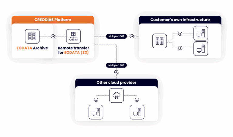
Thanks to the remote transfer service, users can take advantage of multiple 10GE of CloudFerro infrastructure bandwidth, enabling throughput even up to 4 Gbps!
Data consumption is billed at €37 per 1 TB of data transferred, with billing occurring monthly.
While the service offers high-performance access, please note that the repository is not designed for mass replication and data transfers are subject to defined bandwidth and request-per-minute limits. These limitations are designed to ensure fair usage and optimal performance for all users.
Detailed information on these limits is provided in the table below.
| Monthly transfer rate | Throughput* | Request-per-minute limit** |
|---|---|---|
| Up to signed contract | No limit enforced | 5000 |
*please note that your throughput will be dependent on your filesystem client, internet connection and current traffic on the connection endpoint
**for higher request rate limits please contact our sales team
For quotes and access to our solution, contact our sales department at sales@creodias.eu or through our contact form.
Please note that access to Copernicus data is always open and free for everybody. The additional service regards external data transfers to remote customer locations. Within the CREODIAS cloud, users can use the data for free and also anybody can download satellites products via our Data Explorer tool.