


We are pleased to invite you to our upcoming webinar designed to present you a practical introduction to Earth Observation in the cloud.
Join us for a practical introduction to Earth Observation in the cloud, where data, catalogues, and infrastructure form a single analytical ecosystem. The session will demonstrate how EO data can be discovered, explored, and processed directly in the cloud using real use cases and hands-on workflows.
The session is technical, but presented in an end-to-end manner, focusing on how all components work together.
WHEN: Wednesday, January 14th, 14:00 CET
DURATION: 60 min + Q&A
> This webinar is for:
- data analysts and data scientists who want to work with Earth Observation (EO) data without downloading it locally
- GIS and remote sensing specialists interested in modern, cloud-based approaches to data discovery and processing
- IT, cloud, and DevOps engineers who want to see practical use of virtual machines, Kubernetes, and object storage in an EO context
- students and PhD candidates in technical fields (GIS, geoinformatics, computer science, data science)
- people starting their journey with the Copernicus / CDSE / CREODIAS ecosystem, who want to understand the full stack: data, catalogue, and infrastructure
- participants of the Geospatial Innovation Competition for the best solutions and apps that rely on spatial data
> What you will learn:
- understand what data is available in the CREODIAS platform
- use data access points such as CREODIAS Data Explorer, the OData catalogue, STAC, effectively for data discovery
- perform data discovery and exploration in Jupyter notebooks without downloading the data
- understand how virtual machines, Kubernetes, and object storage form a coherent analytical environment
- launch and configure a virtual machine using the CloudFerro dashboard
- understand the basics of infrastructure as code, using Terraform and Kubernetes
- learn from real business and research use cases based on EO data

Technical presentation - agenda
- CloudFerro & the EO Ecosystem
An introduction to CloudFerro Cloud and the CREODIAS platform. - From Projects to Practice
How data, catalogues, and infrastructure come together in real-world EO workflows. Overview of CloudFerro’s projects and examples of real-world applications. - EO Data in the Cloud
Available datasets and how to access them efficiently without local downloads (CREODIAS) - Data Catalogue & Discovery
Using CREODIAS Data Explorer, the OData, STAC, and Jupyter for fast and effective data discovery. - Cloud Infrastructure for EO
Virtual machines, Kubernetes, and object storage as a unified analytical environment. - Real-World Use Cases
Practical examples including oil spill monitoring and AI-powered data discovery. - Key Takeaways & Q&A
CREODIAS as a complete, ready-to-use Earth Observation stack - combining data, catalogues, and cloud infrastructure.
Presenters

Marcin Niemyjski
Data Scientist at CloudFerro
Marcin is an Earth Observation Data Engineer with a strong focus on cloud computing and geospatial data processing. Works on turning raw satellite imagery into reliable, analysis-ready datasets by building scalable services, optimizing data pipelines, and enabling seamless access to Earth Observation data for real-world applications.
Tomasz Furtak
Junior Data Scientist at CloudFerro
Tomasz focuses on Earth Observation data cataloguing and cloud-based processing, with particular expertise in the STAC standard. Works on analyzing Copernicus data, developing practical EO use cases, and exploring very high-resolution datasets from Copernicus Contributing Missions. Involved in metadata standardization activities supporting the Copernicus Programme.

Bartosz Staroń
Junior Data Scientist at CloudFerro
Bartosz works with Earth Observation data cataloguing based on the STAC standard, GIS analyses, and cloud-based EO data processing. Uses Python to support scalable data workflows and geospatial analysis for a variety of EO-driven applications.

Bartosz Augustyn
Junior Data Scientist at CloudFerro
Bartosz is involved in R&D activities related to Earth Observation data embeddings. Works with Python and GIS tools, combining data science methods to support the development of innovative EO products.
The results of the sixth edition of the international “Seize the Beauty of our Planet” contest organised by CloudFerro have been announced. Online voters and a jury comprising representatives of Earth observation organisations selected twelve satellite images that most powerfully depict the intricate relationship between cities and the natural environment. The first place on the podium went to an scientist from Portugal.
The theme of this year’s competition – “Cities and Nature” reflects the growing need to take action to protect the areas inhabited by a majority of the Earth’s population. According to the UN projections, by 2050 nearly 70% of the global population will reside in urban areas, while in Europe this proportion is expected to exceed 83% .
Today’s urban areas increasingly struggle with shrinking green spaces, rising temperatures, air pollution, water scarcity, extreme weather events, and chaotic spatial development – challenges that shape everyday life for their inhabitants and demand better integration of nature within the urban fabric. Cities – key hubs of innovation and development – are simultaneously becoming focal points of mounting environmental pressure. This stems from their rapidly increasing greenhouse gas emissions, which already account for 75% of the global total .
The entries submitted to the contest capture the challenges of today’s cities: from Copenhagen retreating from encroaching waters, through Manila grappling with pollution and chaotic urbanisation, to Longyearbyen, the Arctic settlement where thawing permafrost lays bare the accelerating pace of global warming.
The top three winners are:
- 1st place: „Copenhagen’s Golden Veins of Urban Life: A Model for Climate-Ready Cities” by Lukumon Lateef (Portugal).
The description provided by the author: “This Sentinel-2 image of Copenhagen, Denmark, home to about 1.4 million urban residents, shows how green life weaves through one of Europe’s most liveable capitals. The image composite, created from the infrared and blue bands, highlights vegetation in vibrant golden yellow tones, depicting the city's extensive network of parks, street trees, and other urban vegetation. This stands out against the light blue patterns of urban structures (buildings, roads, and rail corridors) and the deep blue of surrounding waters, including Copenhagen Harbor and surrounding channels. The image captures the balance between a thriving urban area and its green infrastructure, which demonstrates how urban design and nature can coexist”.
“I chose Copenhagen because it consistently ranks among the world’s most environmentally forward cities, and the Sentinel-2 imagery instantly reveals why: its network of parks, tree-lined streets, and urban vegetation reflects a city designed with nature at its core. This confirms Copenhagen’s commitment to sustainability and serves as a global model for a climate-resilient urban environment” – says Lukumon Lateef, GIS Analyst and Remote Sensing Specialist. “I joined the contest because it was an opportunity to show, through satellite imagery, how thoughtful urban planning and natural systems can coexist” – he adds.
- 2nd place: “Vancouver – Harmony of People and Nature” by Kamil Onoszko (Poland).
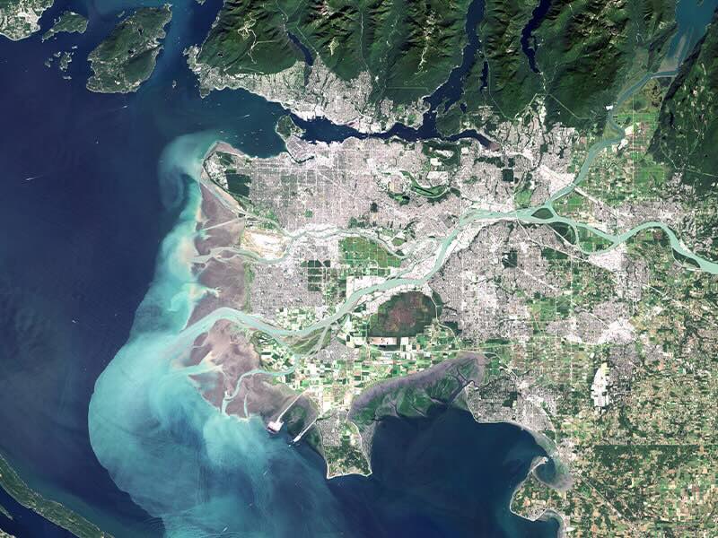
The description provided by the author: “Vancouver, a Canadian city, where urban life coexists in harmony with nature. The satellite image reveals the balance between city, river, ocean, and mountains, showcasing a space that promotes well-being and high quality of life.”
"I chose Vancouver because it consistently ranks among the happiest cities in the world, as confirmed, for example, by the latest Happy City Index 2025 (Institute for Quality of Life)” – explains Kamil Onoszko, Deputy Forest District Manager of the Giżycko Forest District in Poland. “The city is renowned for its breathtaking natural landscapes. The key to this success is its innovative urban policy, which places the residents' quality of life at its core, manifested through the creation and maintenance of an abundance of green spaces and parks. Vancouver harmoniously combines intensive economic growth with a deep commitment to environmental stewardship, setting an example of a welcoming and sustainable place to live" – he adds.
- 3rd place: “Just A River Apart” by Ankur Negi (India)
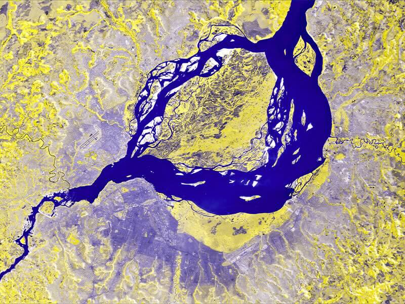
The description provided by the author: “Nature sometimes dictates man’s boundaries. The river Congo separates two capital cities: to the south of the river lies Kinshasa, capital city of the Democratic Republic of Congo; to the North lies Brazzaville, the capital city of Congo. From a bird’s-eye view, the two cities appear as one—only the meandering of the Congo River separating them into two.”
“I chose this particular image because it captures, with striking clarity, how human boundaries are often shaped and sometimes dictated by nature. Water bodies, mountains, and other geographic features have long influenced the way we draw our boundaries, and this image illustrates that influence across international boundaries” – highlights Ankur Negi, a GIS professional specializing in urban climate and disaster management. “In a time when climate change is redefining coastlines, disrupting cities, and challenging how we view our cities, the image serves as a reminder that nature ultimately sets the terms” – he adds.
In this edition, the contest not only presented remarkable satellite images, but also encouraged the international community of researchers, urban planners, and environmental specialists to consider the effects of urbanisation on the natural world. At a time of rapid urban expansion and increasingly frequent extreme events driven by climate change, examining densely developed areas and their influence on local ecosystems becomes significant.
The focus on the relationship between cities and nature underscores the growing need for responsible spatial planning and landscape conservation – fields in which high-quality satellite data can play a crucial role. Local governments and municipalities are now using satellite data not only to monitor environmental change, but also to support long-term spatial planning, enabling them to better prepare their cities for the future. High-quality Earth observation data is becoming indispensable for designing greener, more climate-resilient urban landscapes.
The awarded images were created using data from the European Copernicus programme, sourced from the Copernicus Sentinel satellites and processed on EO platforms, such as CREODIAS, Copernicus Data Space Ecosystem, WEkEO, CODE-DE or EO-Lab. Satellite data help monitor phenomena such as the disappearance of green areas, changes in water retention, the expansion of urban infrastructure and risks associated with extreme weather events.
The winners were chosen through a two-stage voting process: 12 finalists were selected by the public in an online vote, and the final top three were chosen by the competition’s Jury, consisting of outstanding experts in science, technology, and Earth observation: Simonetta Cheli, the European Space Agency (ESA); Lothar Wolf, the European Organisation for the Exploitation of Meteorological Satellites (EUMETSAT); Dr Marta Wachowicz, the Polish Space Agency (POLSA); Emmanuel Pajot, the European Association of Remote Sensing Companies (EARSC); Prof. Katarzyna Dąbrowska-Zielińska, the Polish Institute of Geodesy and Cartography (IGiK); and Dr Jędrzej Bojanowski, CloudFerro.
We are pleased to invite you to our upcoming webinar designed to help you take your first steps with CloudFerro cloud services on the CREODIAS platform.
In this session, our expert will walk you through the entire process – from setting up your account and creating a project to launching virtual machines and managing storage volumes. You’ll pick up practical tips that will help you understand the CREODIAS platform better and use cloud resources more efficiently.
This webinar is the first in a series of technical sessions, each focused on practical aspects of the CREODIAS platform and its technical components.
WHEN: Thursday, 25 September 2025, 11:00-12:15 CEST
DURATION: 60 min + 15 min Q&A
> This webinar is for you, if:
- you are using Copernicus Data Space Ecosystem and need cloud computing power to process Earth Observation data,
- you are starting your journey with CREODIAS and seeking a platform that combines immediate access to EO data with cloud computing capabilities for its processing,
- you are participating in the Geospatial Innovation Competition for the best solutions and apps that rely on spatial data,
- you are looking for practical, hands-on guidance to start using CloudFerro cloud on CREODIAS.
> What you will learn:
- The range of cloud services available on the CREODIAS platform.
- How to access CREODIAS and set up essential resources: virtual machines, security groups, and public IP addresses.
- How to connect to VMs via SSH from Linux.
- How to create and manage storage volumes and integrate them with your virtual machines.
Technical presentation - agenda
- The overall review of resources and platform interface.
- General preparation (how to setup an account).
- Cloud computing resources introduction (regions, flavours, range of services – compute, storage, k8s and more).
- Technical instructions:
- creating a VM with a connection to EO data network,
- security Group configuration and assigning public IP address,
- connecting to a VM via SSH with Linux,
- demonstration of how an automatically configured connection to EODATA works,
- creating a volume,
- creating a partition, file system and mounting the volume to the VM.
- Q&A session.
Presenter

Mateusz Ślaski, Sales - Technical Support Engineer, CloudFerro
Mateusz is a technical expert with over 20 years of experience. He supports customers in adopting CloudFerro infrastructure, tests platform capabilities, and co-leads proof-of-concept implementations.
The Distributed Open Marketplace for Europe (DOME) project, funded under the EU’s Digital Europe Programme, is building a unified European platform where businesses, public institutions, and research organisations can discover, compare, and access verified digital services. Its goal is to simplify and accelerate digital transformation by creating a federated marketplace,
a network of interconnected platforms that share a common framework for interoperability, trust, and compliance.
The DOME project brings together almost 40 organisations (including CloudFerro) from 14 EU countries spanning large enterprises, SMEs, research institutes, certification bodies, and non-profit organisations.
The benefits of the DOME Marketplace reach multiple stakeholders:
- Cloud and “as-a-service” providers gain interoperability, automation, and market reach.
- Data owners can securely monetise their assets.
- Consumers can easily find, deploy, and manage services.
- Marketplace operators can aggregate offerings with transparent billing.
By joining the DOME ecosystem, CREODIAS gains greater visibility among new audiences who may not yet be familiar with its powerful capabilities for accessing and processing Earth Observation data.
The DOME Marketplace platform aims to ensure that trusted, high-quality services such as CREODIAS are just a click away for anyone who needs them.