


MODIS Data Collections now on CREODIAS
Author: Tomasz Furtak (Data Scientist, CloudFerro)
MODIS Data Collections Now Available on Copernicus Data Space Ecosystem (CDSE) and CREODIAS Computing Infrastructure
Satellite Earth observation has become one of the primary sources of environmental information, powering early warning systems, predictive models, and spatial analyses across a wide range of scales. At the same time, rapid technological advancement has made these data increasingly accessible and actionable. Their diversity in spatial, temporal, and spectral resolution enables both local and global assessments of ecosystem changes, land degradation, and climate-driven transformations. NASA's Moderate Resolution Imaging Spectroradiometer (MODIS) mission has provided a continuous backbone for environmental and ecosystem research for over two decades. Operating through the Terra and Aqua satellites, it offers one of the most long-term and consistent Earth observation datasets currently available. A key selection of MODIS collections is now available within the CDSE and CREODIAS data repository, making this dataset directly accessible for research and operational use. The primary strength of MODIS lies in its 25-year record of continuous, sensor-consistent Earth observations. Unlike many missions that rely on the succession of different sensors, MODIS has maintained data stability since 2000 through the Terra and Aqua platforms. This continuity, combined with a high revisit frequency of 1 to 2 observations per day, allows for the detection of environmental trends and rapid changes that other missions might miss.
Such a high revisit frequency is made possible by a wide swath width of 2,330 km. However, the use of such a wide swath comes at the cost of moderate spatial resolution, ranging from 250 to 1,000 m depending on the product. Alongside moderate spatial resolution, MODIS offers a remarkably rich spectral resolution, capturing data across 36 spectral bands spanning from visible light to thermal infrared. This broad spectral range enables the derivation of a wide variety of geophysical parameters, from vegetation indices and land surface temperature to snow cover and burned area, making MODIS one of the most flexible optical sensors. For this reason, MODIS data are especially well-suited for regional and global analyses where observational frequency, spectral richness, and spatial coverage take priority over fine spatial resolution. This design also results in relatively small file sizes. Individual MODIS products typically weigh tens of megabytes, making them relatively lightweight and straightforward to process, which is a particularly valuable characteristic when working with long time series spanning years or decades.
MODIS data are stored in a specific coordinate reference system known as the Sinusoidal projection, and organized into a regular tiling grid, where each tile is uniquely identified by a horizontal and vertical index. This structure simplifies the search and retrieval of data for a specific area of interest, eliminating the need to work with global files. It should be noted, however, that this projection is not commonly used in GIS workflows, which in practice means that reprojection to more standard coordinate systems such as WGS84 or UTM is typically required before further processing can take place. MODIS data are primarily distributed in HDF4 format, which allows multiple layers and metadata to be stored within a single file.
Products derived from this mission are structured across different processing levels, each representing a different degree of transformation from raw observations to analysis-ready outputs. Level 1 data contain calibrated and geolocated radiance values, the closest representation of what the sensor physically measured, and are primarily used for custom processing pipelines or atmospheric correction workflows. Level 2 products introduce geophysical variables such as surface reflectance or land surface temperature, though they remain in the original swath geometry, which can complicate spatial analysis. While these lower-level products form the foundation of the MODIS processing chain, the collections available within the CDSE and CREODIAS repository focus on the higher-level L3 and L4 products, gridded, temporally aggregated, and thematically diverse, covering everything from vegetation indices and snow cover to gross primary productivity and burned area. These higher-level products are especially valuable for a broad range of users, from researchers conducting long-term ecosystem studies to operational services requiring ready-to-use environmental indicators, as they require minimal preprocessing and can be integrated directly into analytical workflows.
The following table provides an overview of the MODIS collections currently available within the CDSE and CREODIAS repository, covering a broad thematic range, from surface reflectance and vegetation indices to evapotranspiration, fire detection, and land cover, across both Terra, Aqua, and combined platforms.
| MODIS Collection ID | Name | Level | GSD |
|---|---|---|---|
| MOD09A1 / MYD09A1 | MODIS Surface Reflectance 8-Day | L3 | 500 m |
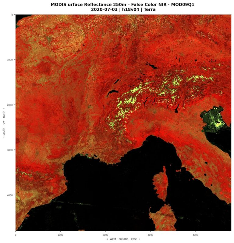
| MOD09Q1 / MYD09Q1 | MODIS Surface Reflectance 8-Day | L3 | 250 m |
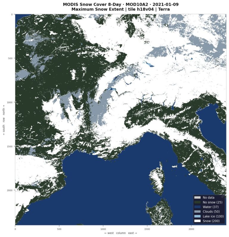
| MOD10A1 / MYD10A1 | MODIS Snow Cover Daily | L3 | 500 m |
| MOD10A2 / MYD10A2 | MODIS Snow Cover 8-Day | L3 | 500 m |
| MOD11A1 / MYD11A1 | MODIS Land Surface Temperature/Emissivity Daily | L3 | 1 km |
| MOD11A2 / MYD11A2 | MODIS Land Surface Temperature/Emissivity 8-Day | L3 | 1 km |
| MOD13A1 / MYD13A1 | MODIS Vegetation Indices 16-Day | L3 | 500 m |
| MOD13A2 / MYD13A2 | MODIS Vegetation Indices 16-Day | L3 | 1 km |
| MOD13Q1 / MYD13Q1 | MODIS Vegetation Indices 16-Day | L3 | 250 m |
| MOD14A1 / MYD14A1 | MODIS Thermal Anomalies/Fire Daily | L3 | 1 km |
| MOD14A2 / MYD14A2 | MODIS Thermal Anomalies/Fire 8-Day | L3 | 1 km |
| MOD15A2H / MYD15A2H | MODIS Leaf Area Index/FPAR 8-Day | L4 | 500 m |
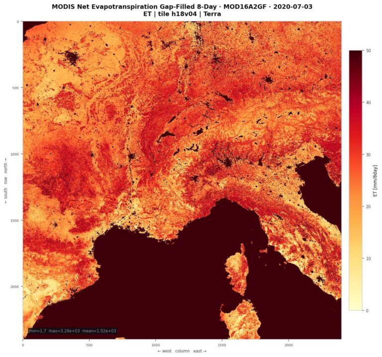
| MOD16A2GF / MYD16A2GF | MODIS Net Evapotranspiration Gap-Filled 8-Day | L4 | 500 m |
| MOD16A3GF / MYD16A3GF | MODIS Net Evapotranspiration Gap-Filled Yearly | L4 | 500 m |
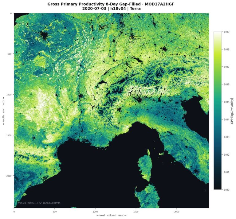
| MOD17A2H / MYD17A2H | MODIS Gross Primary Productivity 8-Day | L4 | 500 m |
| MOD17A2HGF / MYD17A2HGF | MODIS Gross Primary Productivity Gap-Filled 8-Day | L4 | 500 m |
| MOD17A3HGF / MYD17A3HGF | MODIS Net Primary Production Gap-Filled Yearly | L4 | 500 m |
| MOD21A2 / MYD21A2 | MODIS Land Surface Temperature/3-Band Emissivity 8-Day | L3 | 1 km |
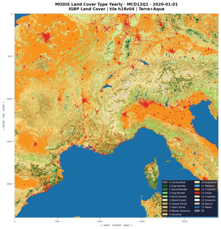
| MCD12Q1 | MODIS Land Cover Type Yearly | L3 | 500 m |
| MCD15A2H | MODIS Leaf Area Index/FPAR 8-Day | L4 | 500 m |
| MCD15A3H | MODIS Leaf Area Index/FPAR 4-Day | L4 | 500 m |
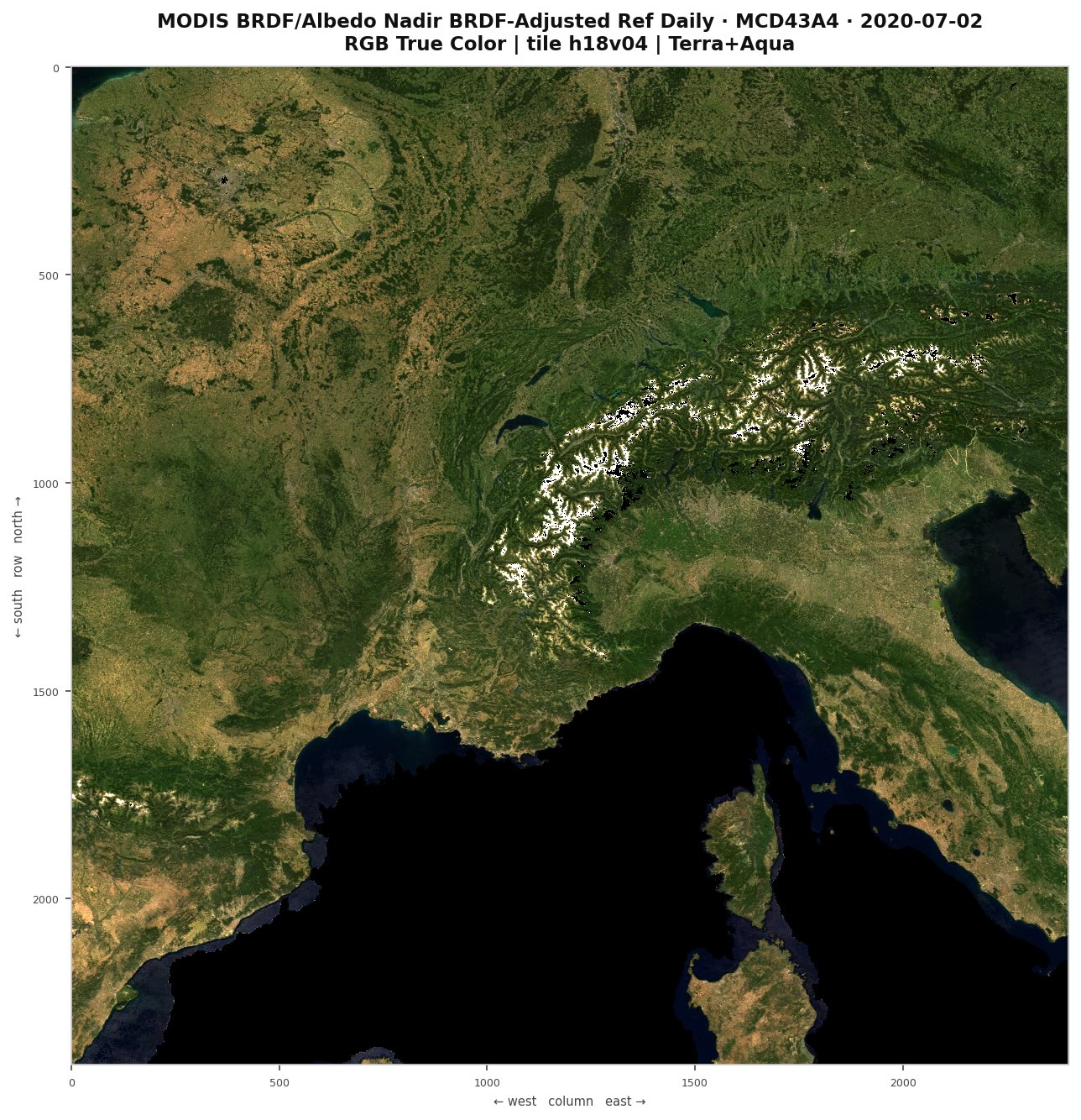
| MCD43A4 | MODIS BRDF/Albedo Nadir BRDF-Adjusted Ref Daily | L3 | 500 m |
| MCD64A1 | MODIS Burned Area Monthly | L3 | 500 m |
MODIS collections available within the repository are accessible through several access points. The data are stored in an S3 object storage, which allows direct and efficient access to files without the need for intermediate processing layers. The CREODIAS repository also provides two API interfaces, OData and STAC, through which data can be explored, filtered, and retrieved. STAC is a newer standard designed specifically for satellite and geospatial data, offering better integration with modern analytical tools. Both interfaces provide access to metadata at the level of individual files, which significantly supports data selection and inspection prior to download. You can also explore use cases related to API access and thematic analysis. These include examples focused on surface reflectance and land cover analysis applied to deforestation monitoring in Brazil using OData, and desertification assessment in Andalusia, Spain using STAC (SpatioTemporal Asset Catalog). A complementary feature of the repository is its computing infrastructure, such as virtual machines with integrated access to all stored data, which removes the need to copy data to external systems, speeds up processing, and allows efficient work with large data volumes directly within the repository environment. You can also explore Jupyter Notebook examples of this type of analysis, including a multi-year snow cover study of the Italian Alps using OData and a fire episode analysis based on the STAC API in Portugal. Both examples run entirely on repository virtual machines, making direct use of this infrastructure.
Use cases:
While the MODIS mission has proven to be one of the most long-lasting and scientifically productive Earth observation programs, both Terra and Aqua are well beyond their designed operational lifetimes and may stop functioning at any point. Their successor, the VIIRS instrument, was intentionally designed to ensure continuity with MODIS, offering comparable spectral coverage, similar product families, and improved spatial resolution in several bands. As the transition from MODIS to VIIRS gradually progresses, the two missions increasingly function as a complementary pair, enabling the construction of extended time series that connect observations from both sensors and support long-term environmental monitoring. In recognition of this growing importance, VIIRS collections are planned to be incorporated into the CREODIAS repository in the near future, further expanding the scope of available long-term satellite data.